Pages

Showing posts with label Snowshoeing. Show all posts

Sunday, May 19, 2013

Snowshoeing Flattop Mountain

Snowshoeing Flattop Mountain


On the 4th of May, Brad Cook and I  snowshoed up the Flattop Mountain Trail.  Flattop is a 12,324 foot peak and is one of the most popular hikes in Rocky Mountain National Park because it's one of the easiest ways to reach the Continental Divide.  The Flattop Mountain Trail is a Grade I, Class 1 hike.


The trail can easily be connected with other trails to several other destination trails.  We started from Bear Lake, but there are a few other trail head options including Grand Lake.  So you could connect the two for a through-hike from Bear Lake to Grand Lake.  Wouldn't that be fun!


The trail starts in the northeast corner of Beak Lake and heads northeast for about a half mile, then turns west (left) at a trail junction.  From here you are heading almost straight west for another half mile, to the Fern-Odessa Trail junction.


From the junction, you head southwest and the trail begins to climb up through the forest to an overlook of Dream Lake.  This portion of the trail offers great views of the surrounding peaks.  Here's a shot toward Longs Peak, which is shrouded in clouds.


From here, the trail turns back to the northwest and climbs up through trees that become more stunted as you climb.  


Here's a shot of Brad with a view back to the east behind him.  There is another overlook of Emerald Lake where I snapped a quick pic of the Tyndall Gorge.


The face of the Hallett Peak ridge is very impressive!  The trail continues to zigzag in a generally westward direction by switching between northwest to southwest.


Brad and I didn't make it to the summit because we had a firm turn-around time, but we made it to about 11,900 feet or so.  We had a great time getting to know each other and the weather was just perfect with very little wind, which is very rare in this area.  We met exactly two people on the trail, both were skiing.

Saturday, April 20, 2013

Snowshoeing Finch Lake Trail

Snowshoeing Finch Lake Trail


 Finch Lake Trail is located in the Southeast corner of Rocky Mountain National Park in the Wild Basin area, near Allenspark.


During winter months, you have to park at the Winter Recreation Parking area, which adds an extra mile to the hike.  In the summertime, you can park right at the trailhead.


I figured that this weekend might be one of the last chances to get out the snowshoes for the season.


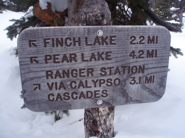
The trail crisscrosses a couple of other trails and you can continue on past Finch Lake to Pear Lake.


If you were really ambitious, you can even continue on to the Cony Lakes or even on the Cony Pass.


The road from the Winter Recreation Parking area to the trailhead was well packed and icy when I headed out around 6:15 AM.  Above is a snapshot of what the trailhead looked like when I made it there.  There was one set of tracks that went just far enough to realize that no one else had traversed the trail since the recent 54 inches of snow they received this week and then they must have turned around.


Somebody has to be the first one, right?


One thing I love about snowshoeing in fresh powder is all the evidence of the local wildlife's scampering about.  Anybody care to name the owner of these tracks?


Even with my 930s, I was still post-holing really deep.  Up to two feet sometimes.  On one extreme drift, oen of my trekking poles, set at 125 cm, sunk in all the way to the grips!


When I made it to the nose of the ridge, I had a good view of Meeker and Longs.  The peaks were obscured by clouds off and on all day.


On the other side of the ridge, the snow switched from soft, undisturbed powder to windblown, sunshine crusted fun.  Even if it isn't as deep, this stuff is harder to trudge through because it initially holds your weight and then breaks through and you have to absorb the sudden sinking through the powder underneath.  There are some nice groves of Aspens on this side as well.


The tail is well marked at the major trail junctions.  Keep heading west.


A portion of the trail comes close to a steep slope where you have some terrific views of the valley below and the peaks opposite, if the clouds don't keep them shrouded.


I got a little off trail to take some pictures and was struggling to find my way back to the trail.  Instead of doubling back, I whipped out my map and compass to figure out if the trail was above or below me and I easily found my way back to the trail.  My CMC Boulder instructor would have been so proud!


There is another trail junction where you can choose to head straight West and downhill to Calypso Cascades, which is a series of short falls along Cony Creek just before it dumps into Ouzel Creek.


My progress was so slow in the deep powder that I was still about a mile from Finch Lake when I decided to call it a day and about-face shortly after noon.


About 1:45 PM, just after I had rounded the nose of the ridge on the way back, it began to snow on me, just a light dusting at first and slowly increased to a winter wonderland!

Monday, January 7, 2013

Snowshoeing Jenny Creek Trail

SNOWSHOEING JENNY CREEK TRAIL

On Saturday, I did a short day hike up Jenny Creek Trail.  I only had about four and a half hours, so I snowshoed in a couple of hours and turned around.  You can start the hike either from just outside the Eldora Mountain Resort gate or from the Nordic Center at Eldora.  The Eldora Nordic Center is located on the east side of the Ho Hum (bunny slope) run.  The trail begins by climbing up through the trees to emerge at the east end of the Ho Hum run.  You then hike around the top side of the Little Hawk chair lift area and head back into the trees on the other side.  There is a very short, steep hill here and then the trail drops into a gulch.  The trail climbs back up the other side and takes a left turn.


I met a couple of cross-country skiers here and they agreed to take my picture next to the trail sign.  From here the trail drops again toward a small meadow, then on a nice steady decline down toward the creek.


The trail follows the north side of the creek.  For a short distance the path was very narrow, right next to the creek.  It was just wide enough for a pair of nordic skis and was a little tricky to navigate on snowshoes.  On the way back, I saw an alternate path that crossed the creek and then back again, that was much easier.  At around 2.7 miles you encounter the fork that heads up the the Guinn Mountain Spur Trail and around 3.1 miles there is another trail junction.  It looked to me like this is where most people turned around.  I continued to climb for about another mile plus.  I didn't quite make it to Yankee Doodle Lake, but I was out of time, so I turned around and headed back.

The trail is extremely well marked and well traveled.  I met a dozen or so people on the lower part of the trail, but no one on the upper part.  About two thirds of the folks I shared the trial with were cross-country skiers, the rest were snowshoeing.  There are a few spots that offer nice vistas of the surrounding peaks, but most of the trail is dense lodgepole forest.

If you are like me, and looking for more human-powered outdoor adventure, you should check it out!